
Passing through our town, Highway 50 stretches west about fifty miles to Sacramento, and east about three thousand miles to Ocean City, Maryland. It is not the fastest way to drive to the east coast, or even the most interesting, but it is unique. Our neighbors were so fascinated by the sign “Ocean City, MD, 3070 miles” near the Sacramento end that they jumped into their RV and spent a week or so driving to Maryland. We drive in a much more leisurely fashion, and so we have never imitated them.
Originally
Highway 50 was part of the Lincoln Highway that ended in Alameda, on the east
side of San Francisco Bay. The Alameda end is still shown by a marker on
Webster St. (Or at least it was a few years ago, when I was living in Alameda.)
From the Alameda end, drivers could take car ferries across the bay to San
Francisco. The car ferries were discontinued in the 1939, when impatient
drivers could drive across the Bay on the new Oakland–San Francisco Bay Bridge.
Highway 80 has replaced the section of the Lincoln Highway from Sacramento to
San Francisco, and now there are passenger-only ferries on the bay.
For
many travelers Highway 50 is boring, a seemingly endless empty road with no
scenery. Their reaction is somewhat justified. Only in some stretches are there
mountains or other panoramas suitable for photos like those in RV magazines.
For us, however, it is a fascinating highway worthy of inclusion in any RV
itinerary. We have not yet committed ourselves to seeing the entire route, but
have enjoyed driving across Nevada several times. Long stretches of desert are
punctuated by passes through mountains. We have seen petroglyphs and explored
fossil beds .

Driving
from our part of California to Nevada (which takes only a little more than an
hour) is an adventure in itself, because we climb up the west slope of the
Sierra Nevada Mountains and pass above the south branch of the American River.
The mountain scenery is so spectacular that it almost makes us wonder why we
are leaving home. But we forge on.
South
Lake Tahoe is the first city we reach in Nevada; it borders beautiful Lake
Tahoe, straddles the state line between California and Nevada, and provides a
striking contrast between the two states. In California, the town is fairly
rustic (though becoming more and more upscale). One of our favorite public
libraries is there—it has huge windows facing the lake, and there is space for
our 24’ RV in the free parking lot.
On
the Nevada side, South Lake Tahoe is lined with flashy casinos and looks a lot
like Reno or Las Vegas. Not being gamblers, we usually drive through it
quickly, but we did once spend the night in a casino parking lot. Highway 50
curves to the right here, and goes on to Carson City.
Nevada’s capital, Carson City, is about 30
miles south of Reno. It was developed during the nineteenth-century silver
strike in the Comstock Lode and named for mountain man Kit Carson. The nineteenth-century
architecture and period-piece stores make it a good place to visit. My partner,
a train buff, especially enjoys the Nevada Railroad Museum. At one time the
Virginia and Truckee Railroad ran to Virginia City, and some day we surely will
visit that city. (I have seen all too many railroad museums in the past few
years, and hope there is something else for me to do there.)
The next city along eastbound Highway 50 is Silver Springs. We have never happened to stop there, but Googling indicates that some spots of possible interest to RVers are near by: the Lahontan Reservoir and State Recreation Area, and historic Fort Churchill State Historic Park.
The next city along eastbound Highway 50 is Silver Springs. We have never happened to stop there, but Googling indicates that some spots of possible interest to RVers are near by: the Lahontan Reservoir and State Recreation Area, and historic Fort Churchill State Historic Park.
Fallon
is a frankly ugly city with many casinos and old motels, but it has a good
library. (We rely heavily on libraries as we travel, for local information and
Wi-Fi.) After Fallon, Highway 50 truly begins to justify its nickname of “the
loneliest highway in America.” We enjoyed the Shoshone gas station, where the
roof over the gas pumps is supported by huge concrete “tree trunks.” Buying
gas in Fallon can be critical, for the next town (Austin) is 110 miles to the
east.
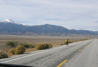
That
110 miles can seem much longer. The apparently endless sagebrush-bordered road
stretches off to the east, and is usually spookily empty. City dwellers may
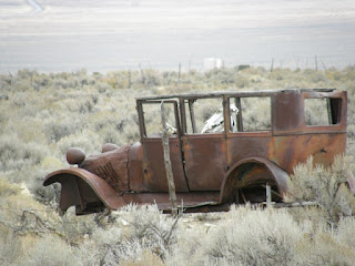
find Highway 50 very unsettling along here. Hamilton and other towns that thrived
here after the silver rush are all gone now. We find the scenery enthralling,
with the vast skies making nighttime stargazing easy.

Just
west of Austin, we have noted signs to Big Creek campground and to
Berlin–Ichthyosaur State Park (which is 56 miles to the south of Highway 50).
We plan to stop at both of them in the future.
Nevada’s
silver rush began in 1862 and lasted only about twenty years. In the 1950s
uranium mining had a short run, as have gold and silver throughout the years.
Turquoise mining is still popular, with turquoise jewelry being widely
available here. Austin is still preserved as a sort of frontier “ghost town,”
with many spots on the National Register of Historic Places.
East
of Austin, we once stayed at the USFS Bob Scott campground. It had not been
well cared for (the toilets were very
messy!), but was free and in a pleasant location. When you travel by RV on a
low budget, you aren’t terribly fussy. By now I can hope the water and toilets
are operating, even though the campground is probably not free any more. Across
the highway from the campground, a historical plaque, “The Surveyors,” honors
the U.S. surveyors who mapped vast areas from Nevada to the Pacific in 1859 and
1860.
Looking
down on Austin from the mountains to the east, you see an attractive little
town, with only the western mountains providing relief from the cold-desert
plant life where a few cattle graze.


Because
Highway 50 passes along much of the old Pony Express mail route, several old
station ruins can be seen along the road east of Austin. (Back near our home in
California, one of the original stations has been preserved and is still used
as the Sportsman’s Hall restaurant.)
One
of our favorite stops along Highway 50 is the Hickison Petroglyphs Recreation Area, a BLM area 24 miles east of Austin. Hickison has free campsites and nice
toilets. There is no water available, but with a little planning that isn’t a
problem for RVers. There are ancient petroglyphs and hiking trails that we
enjoyed.
 Eureka lived up to its “friendliest city” motto
for us on a return trip from Utah. I was planning to take Amtrak home from Reno
(while my partner drove the View back alone), but needed to print out a train
ticket ahead of time. In Eureka, the public library—our usual stopping place
when we need help—was closed that day, so we went to the local senior center
and asked if they had an Internet connection we could use. Not only did they
allow us to do so, but they printed out the train ticket, which was a fairly
complicated transaction. And then they recommended a local mechanic who could
do a minor repair on our RV!
Eureka lived up to its “friendliest city” motto
for us on a return trip from Utah. I was planning to take Amtrak home from Reno
(while my partner drove the View back alone), but needed to print out a train
ticket ahead of time. In Eureka, the public library—our usual stopping place
when we need help—was closed that day, so we went to the local senior center
and asked if they had an Internet connection we could use. Not only did they
allow us to do so, but they printed out the train ticket, which was a fairly
complicated transaction. And then they recommended a local mechanic who could
do a minor repair on our RV!

The senior center was not the only attraction in
Eureka, of course. An old city founded by silver prospectors in the 1800s, and
the county seat of Eureka County, it boasts the restored Eureka Opera House,
the Jackson House Hotel, and the Eureka
Sentinel newspaper building, all built in the nineteenth century The Eureka
Sentinel Museum is housed in the newspaper building. We strolled along the main
street while waiting to take the RV to the mechanic. All in all, we have very
fond memories of Eureka and the helpful workers at the senior center.
About 20 miles east of Eureka, a rather odd tall
tree rises out of the sand and rock along the north side of the road. Strange
leaves or cones appear to dangle from its branches. Closer inspection shows
that these objects are shoes: thousands
of old shoes that have been thrown (or perhaps catapulted in some cases) onto
the high branches. Apparently bored travelers have been disposing of worn-out
shoes there for many years. On one recent trip we added a pair of our own.


Here in the Great Basin, the climate is cold and
dry in winter, hot and dry in summer. In spite of the dryness, snow may
accumulate to several feet annually.
The Illipah Reservoir has a good free campground
with fourteen large, fenced (!) sites. Like most reservoirs in the West, this
one has fallen in size in recent years, but is still popular with fishers.
Ely
was founded as a station along the Pony Express route, and grew large when
copper was discovered near by in 1906. The railroad to Ely, a relic of railroads
connecting the First Transcontinental Railroad to mines, has been preserved as
a heritage railway. Signs along the highway implied that we could ride an old
steam train from the Nevada Northern Railway Museum, so of course we had to
stop. As it turned out, the only train available at the time had a diesel
engine, which was disappointing. We did reluctantly ride the train anyway, for a pleasant journey
that included a staged holdup by masked gunmen.
The Kennecott copper mining company flourished here until the 1970s, when there was a crash in the copper market and Kennecott shut down.. Now copper has regained value, and mining has resumed, with copper concentrate being shipped to Seattle, then sent to Japan for smelting.

Great Basin National
Park, near the eastern edge of Nevada, is apparently less popular than many of
the other national parks, but we greatly enjoyed a quick visit there. One of
the major attractions in the park is the Lehman caves. I am not particularly
fond of caves, but even I was captivated by these. They are far less touristy
than better-known caves, with little damage to the stalactites and stalagmites.
You can see the opening where a pony stumbled, leading to the caves’ discovery.


Elk, black bears,
and other wildlife are found here. The excellent Visitors’ Center is a good place to
start exploring the park. Both the upper and lower campgrounds in Great Basin
are fine places to stay, but only the lower one is accessible for RVs.
Highway
50 continues far to the east of Nevada, and that’s a story for another blog. .
.
All photos (c) 2015 by Thane Puissegur